Ever feel like your stunning architectural visualizations are missing a crucial layer of realism? That final piece is often the real-world context—the actual site, terrain, and surroundings. This is precisely where the power of geospatial data becomes a game-changer.
By integrating live geospatial data, D5 Render is transforming how you create visualizations, moving beyond generic backdrops to build in a dynamic, accurate digital world from the outset.
Key Takeaways on Creating Smarter Architectural Visualization
- D5 Render 's integration with Cesium enables architects to seamlessly incorporate real-time geospatial data, improving the accuracy and realism of visualizations.
- Optimize workflow efficiency by adjusting the 'Maximum Screen Space Error' settings in D5 Render when working with slower internet connections, ensuring smooth utilization of geospatial data.
- Use D5 Render's Level of Detail (LOD) transitions for large-scale projects to maintain performance without sacrificing visual quality.
- Leverage tools like the Section Cube , dynamic weather effects and AI post-processing in D5 Render to enhance design precision and simulate real-world conditions.

1. Why Geospatial Data is Essential in Modern Architectural Workflows?
In modern architecture, geospatial data has shifted from a nice-to-have to an absolute necessity. It provides architects with essential site context—from analyzing shadow impacts to ensuring a building fits its surroundings—enabling smarter decisions and smoother approvals.
For clients, seeing a design placed in its real-world location bridges the gap between concept and reality. Real-time geospatial data turns abstract ideas into relatable visual experiences, making it easier to grasp scale and context before breaking ground.
For firms, integrating tools like D5 Render unlocks the full potential of geospatial data. It elevates presentations , builds client trust, and boosts ROI—all while cutting manual modeling time and accelerating design iteration with live geospatial data.
Want to Win Clients with Visual Presentations? Try These 4 D5 Render Pro Tips
The Limitations of Traditional Methods Without Geospatial Data
Imagine spending hours crafting a beautiful architectural model, only for it to feel disconnected from its intended site. This is the common pitfall of traditional workflows that lack integrated geospatial data. Manually modeling surroundings or piecing together third-party assets from sources like OpenStreetMap often leads to generic, inaccurate contexts.
These methods not only drain time but create a legacy of complexity. Juggling disparate, incompatible data sources makes any future update a tedious task.
D5 Render shatters these limitations by seamlessly embedding real-time geospatial data, empowering architects to build upon a dynamic, precise, and effortlessly updated digital foundation.
2. D5 Render's Solution: The Integration with Cesium
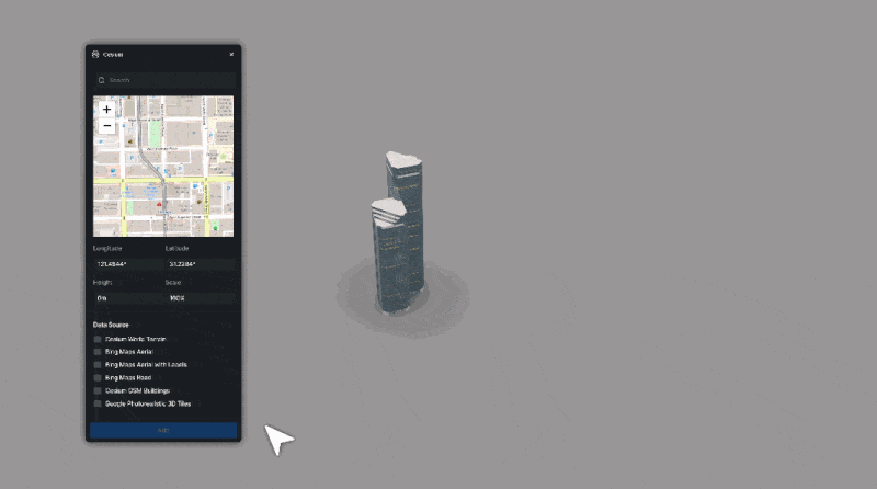
D5 Render has made architectural visualization easier and more accurate by integrating with Cesium , a platform that streams real-world geospatial data directly into design workflows. This integration allows architects to import precise, up-to-date site data into their D5 Render scenes, eliminating the hassle of manual modeling or relying on outdated files.
With Cesium, architects can instantly enhance their visualizations with accurate geospatial data like building layouts, topography, and even trees. This makes it much easier to see how a design will interact with its real-world surroundings.
Best of all, because the data is pulled from Google's expansive database of 3D tiles, architects can trust they're always working with the most current information, ensuring their designs are as realistic and relevant as possible.
How to Use Cesium in D5 Render 2.11 for 3D Mapping (3 Steps)
Top 5 GIS Tools for Next-Level 3D Visualization in 2025
Tips and Tricks for Getting the Most Out of Cesium Integration
D5 Render 's integration with Cesium unlocks a world of possibilities. To truly maximize its potential, here are a few tips and tricks from Jeffrey Espinosa , a Design Technology Consultant at D5 Render, that can help streamline your workflow and enhance the realism of your projects.
① Optimize for Internet Speed
If you're working with a slower internet connection, don't worry! You can easily adjust the 'Maximum Screen Space Error' setting to 100 for a lower-resolution import, which will reduce bandwidth usage without sacrificing too much quality in Cesium within D5 Render . This allows you to work with real-world geospatial data smoothly, even on slower connections.
Note: When working on final renderings, setting the screen space error value to zero will yield the highest quality possible render!
② Enable LOD Transitions in D5 Render
For large-scale projects , D5 Render integrates Cesium 's Level of Detail (LOD) transitions, which automatically adjust the detail of distant objects to improve performance. This feature ensures that your scene remains responsive, even when working with vast areas of geospatial data or an entire 3D city model.

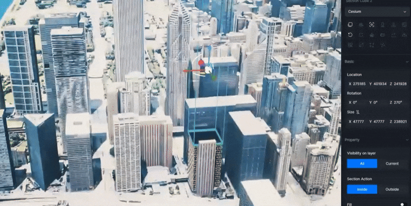
③ Use D5's Section Cube for Precision
If you need to carve out certain parts of the site context, such as removing a building or adjusting the landscape, use D5's section cube tool . This allows for precise adjustments without affecting the main model, ensuring that only the desired elements are visible.
④ Integrate Dynamic Weather
With D5 Render 's powerful built-in weather system, weather changes like clouds, rain , fog , and snow seamlessly integrate with Cesium 's real-world data, allowing you to dynamically switch between seasons or weather conditions and see how your design interacts with the environment.
⑤ Enhance Details with D5 Render's AI Post-Processing
Once you've completed the rendering, continue using D5 Render 's built-in AI post-processing tools to refine and enhance details. Features like the ' AI Enhancer ' can help improve the overall clarity of your scene, giving it a more polished, professional look.
By thoughtfully integrating Cesium 's dynamic geospatial data with the robust toolset in D5 Render , you can craft architectural visualizations that are not only deeply realistic but also rich with real-world context.
We hope these practical tips help make your design process more fluid, your details more defined, and ultimately, your creative explorations more immersive.
3. Practical Applications for Architects and Designers
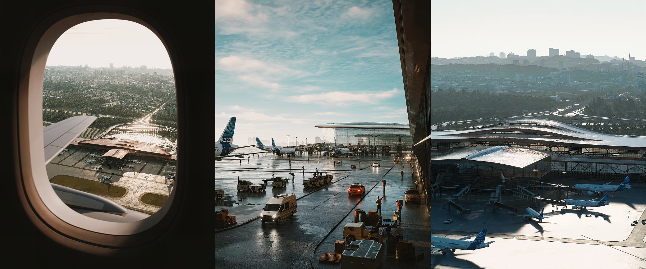
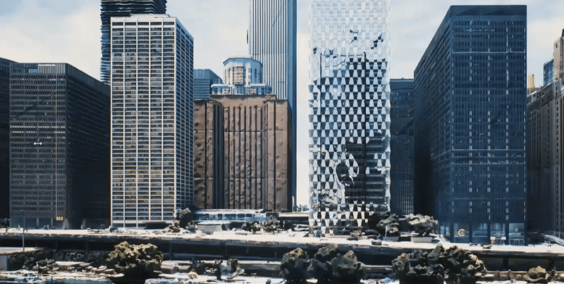
The integration of Cesium into D5 Render has broad applications across many different areas of architectural design. From urban planning and environmental design to large-scale projects and cultural heritage restoration, the ability to instantly import real-world geospatial data into D5 Render makes it a powerful tool for architects working in diverse fields. Vasaka City ©Yoga4Arch | Rendered with D5 Render
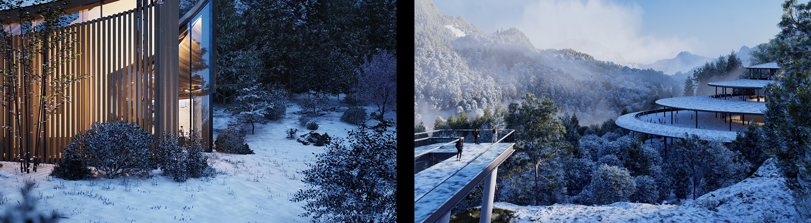
Landscape designers, in particular, benefit from this integration, as it allows them to incorporate large-scale, geographically accurate geospatial data directly into their visualizations. This is particularly useful for projects like parks, urban developments, or other large outdoor spaces where site context plays a crucial role in the design process.
For example, when designing a stadium in an urban setting, architects can quickly import the surrounding environment, ensuring their design interacts harmoniously with its surroundings. Similarly, for cultural heritage projects, the detailed geospatial data ensures designs respect both historical and geographical elements. © archiould_design | Large-Scale Scene Rendered with D5 Render
Conclusion: Embrace the Future with Geospatial Data
It's clear: real-time geospatial data is reshaping architectural visualization, making designs smarter, faster, and more believable. By moving beyond manual modeling and embracing tools like D5 Render , you can create visualizations that truly connect with clients and context.
Ready to build with confidence? Start leveraging live geospatial data in D5 Render today —and turn every project into a precise, immersive experience.
Continue Reading for More Tricks on Architectural Rendering
How to Create Realistic Rain Backgrounds in D5 Render?
5 Secrets to Photorealistic Rendering with D5 Render in 2025
Want to Win Clients with Visual Presentations? Try These 4 D5 Render Pro Tips
The Best Free SketchUp Rendering Tool: D5 Render
AI Enhancer for Architects: Elevating Render Quality with AI-Powered Precision
The 100% ready-to-use crack of D5 Render
FAQ for Creating Smarter Architectural Visualization
Q . How can I improve the realism of my architectural designs?
To enhance realism, integrating geospatial data is key. By using tools like D5 Render with Cesium integration, you can bring accurate, real-world site data into your designs—such as terrain, existing structures, and environmental features. This helps you create designs that are truly rooted in their surroundings, providing a more immersive experience for clients.
Q . How does geospatial data help in large-scale architectural projects?
In large-scale projects, like urban planning or environmental design, geospatial data is invaluable for understanding how a design interacts with its environment.
D5 Render , through its integration with Cesium, allows architects to quickly import vast amounts of real-world data, such as 3D city models or terrain, into their designs. This helps ensure that large-scale projects are well-suited to their surroundings, both visually and functionally.
Q . How does using real-time geospatial data benefit my design process?
Using real-time geospatial data allows for more accurate and efficient architectural workflows. By integrating D5 Render with Cesium, architects can instantly access current, site-specific data, eliminating manual modeling. This reduces errors, speeds up the design process, and ensures that your visualizations are always based on the latest information.
Q . How can I visualize how my design will interact with its environment?
By using geospatial data, you can better understand how your design will interact with its surroundings, from topography to surrounding buildings.
D5 Render and Cesium allow for easy importation of this data into your visualizations, letting you see how the design will look in its real-world context, taking into account factors like shadow and scale.
Q . How can I ensure my large-scale projects are accurate and realistic?
For large-scale projects, using geospatial data ensures your designs are contextually accurate. With D5 Render and its Cesium integration, architects can quickly import 3D models, topography, and other critical data into their designs.
This results in visualizations that are not only accurate but also consider how the project fits into its environment, whether it's a cityscape or a natural landscape.